
Arizona Surveyors, Inc. | Boundary Land Survey
|
Boundary Land SurveyARIZONA SURVEYORS, INC.
A boundary survey is the process of researching and collecting evidence that aid in the determination of an individual or many adjoining property boundaries.
A boundary survey is a high liability survey since is effects the subject property but all the adjoining neighbors and at times entire blocks. There are several different reasons for having a boundary survey done, the most common of which are determining ownership, conflicts with neighbors or during a real estate transaction. |
Boundray SurveysThere are different types of property boundaries, a land surveyor must have extensive knowledge of the most common types.
|
The most common boundary surveys are used for a subdivision lot, an aliquot part of a section, a course description and a bounds description. They all require the same care to determine the land boundary, however some properties require more time than others to research and collect evidence.
Every lot is different and cost will vary on available information at the time of the survey. Generally older areas are tougher to survey in because there is a smaller amount of readily available information and the conditions are more likely to have changed over time. A Land Surveyor cannot determine ownership and can only provide evidence to help establish ownership. Only a court of law can determine ownership. |
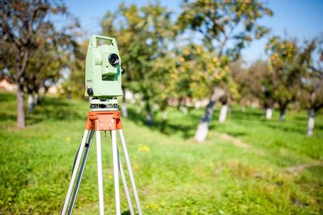
Boundray ReportingThe process begins in the office with a search of available public records and then trip to the field to search for property corners on the subject parcel and adjoining parcels and to collect evidence such as occupation line, walls, fences, shrub lines, improvements, etc.
|
Once the basic reconnaissance data has been gathered from the county and property, the information is then brought into the office and processed in AutoCad to develop a map and determine the land boundary.
The property corners or monuments will generally be marked with a rebar or iron pipe with the Land Surveyors License ID attached to it in the form of a plastic or aluminum cap on top of it or a brass or aluminum tag wired to the side. Whenever it is impossible to set a rebar or pipe a nail will be set with a tag attached such as the case when the location lands in concrete or on a wall, etc. When it is impossible to set the actual corner a Witness corner or Reference Corner will be set to show a tie to the actual location. Upon completion, the surveyor will determine whether a map will need to be filed at the county recorder’s office, state statue dictates this, however even if it is not necessary the client can request this done. When accepting an existing monument, the surveyor will affix a cap or tag to it. | ||||